
Geography, the study of the Earth’s physical features and human activities, has played a crucial role in shaping our understanding of the world around us. Throughout history, countless geographers have made significant contributions to this field, from exploring uncharted territories to developing new theories and techniques for mapping and analyzing the Earth’s surface.
In this article, we will explore the lives and legacies of the top 12 most influential geographers in history. These individuals, through their groundbreaking work and tireless dedication, have left an indelible mark on the field of geography and have helped to shape our understanding of the world we live in today.
From the ancient Greek scholar Eratosthenes, who first calculated the circumference of the Earth, to the modern-day geographer and cartographer Marie Tharp, who helped to map the ocean floor and revolutionize our understanding of plate tectonics, these geographers have made invaluable contributions to the field and have inspired generations of geographers to follow in their footsteps.
Join us as we delve into the lives and work of these remarkable individuals and explore the lasting impact they have had on the field of geography and our understanding of the world around us.
Eratosthenes (276 BC – 194 BC)

Eratosthenes, an ancient Greek scholar and polymath, is widely regarded as one of the most influential geographers in history. Born in Cyrene, present-day Libya, Eratosthenes was a true renaissance man, with interests and expertise spanning a wide range of fields, including mathematics, astronomy, and geography.
One of Eratosthenes’ most significant contributions to the field of geography was his calculation of the Earth’s circumference. Using a simple but ingenious method involving the angle of the sun’s rays at two different locations on the Earth’s surface, Eratosthenes was able to estimate the Earth’s circumference to within a few hundred kilometers of its actual value. This remarkable feat, accomplished over 2,000 years ago, laid the foundation for modern cartography and helped to shape our understanding of the Earth’s size and shape.
Eratosthenes also made significant contributions to the field of cartography, creating one of the first maps of the known world based on a system of parallels and meridians. His work in this area helped to establish the basic principles of map-making and laid the groundwork for future generations of cartographers.
In addition to his work in geography and cartography, Eratosthenes was also a prolific writer and scholar, with works spanning a wide range of subjects, from poetry and philosophy to mathematics and astronomy. His interdisciplinary approach to knowledge and his tireless pursuit of understanding have made him a role model for generations of scholars and a true icon of the ancient world.
Ptolemy (c. 100 AD – c. 170 AD)

Claudius Ptolemy, a Greco-Roman scholar and geographer, is another of history’s most influential geographers. Born in Alexandria, Egypt, Ptolemy lived and worked during the height of the Roman Empire, and his contributions to the field of geography have had a lasting impact on our understanding of the world.
One of Ptolemy’s most significant works was his “Geographia,” a comprehensive treatise on geography that included detailed maps of the known world, as well as discussions of the Earth’s size, shape, and position in the universe. Ptolemy’s maps, though based on limited and often inaccurate information, represented a significant advance in cartography and helped to shape the way Europeans viewed the world for centuries to come.
In addition to his work in cartography, Ptolemy also made significant contributions to the field of geography through his development of the concept of latitude and longitude. By using these coordinates to specify the location of places on the Earth’s surface, Ptolemy laid the foundation for modern geographic information systems and helped to revolutionize the way we think about and represent spatial data.
Ptolemy’s work also had a significant impact on the field of astronomy, with his “Almagest” serving as the standard astronomical text for over a thousand years. His geocentric model of the universe, though later proven incorrect, represented a significant advance in our understanding of the cosmos and helped to shape the way we think about our place in the universe.
Al-Idrisi (1100 AD – 1165 AD)
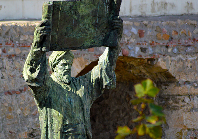
Abu Abdullah Muhammad al-Idrisi, commonly known as Al-Idrisi, was a Muslim scholar and geographer who lived and worked during the 12th century. Born in Ceuta, present-day Spain, Al-Idrisi was a true polymath, with expertise spanning a wide range of fields, including geography, cartography, botany, and medicine.
One of Al-Idrisi’s most significant contributions to the field of geography was his creation of the “Tabula Rogeriana,” a world map commissioned by King Roger II of Sicily. The map, which was completed in 1154 AD, was based on a combination of Islamic and European geographic knowledge and represented a significant advance in cartography. The Tabula Rogeriana was divided into 70 sections, each representing a different region of the known world, and included detailed descriptions of the physical and human geography of each area.
In addition to his work on the Tabula Rogeriana, Al-Idrisi also wrote extensively on the subject of geography, with his “Kitab nuzhat al-mushtaq fi’khtiraq al-afaq” (The Pleasure Excursion of One Who Is Eager to Traverse the Regions of the World) serving as a comprehensive guide to the geography of the known world. The book included detailed descriptions of the physical and human geography of each region, as well as discussions of the customs, beliefs, and ways of life of the people who lived there.
Al-Idrisi’s work had a significant impact on the field of geography, both in the Islamic world and beyond. His maps and writings helped to shape the way people viewed the world for centuries to come and laid the foundation for future generations of geographers and cartographers.
Ibn Battuta (1304 – 1368)

Ibn Battuta, a Moroccan scholar and explorer, is widely regarded as one of the greatest travelers of all time. Born in Tangier, Morocco, Ibn Battuta set out on a pilgrimage to Mecca in 1325 and spent the next 29 years traveling throughout the Islamic world and beyond, covering an estimated 117,000 kilometers and visiting over 40 countries.
Throughout his travels, Ibn Battuta kept detailed records of the places he visited and the people he encountered, providing a unique and invaluable glimpse into the world of the 14th century. His accounts, compiled in his “Rihla” (Journey), offer a fascinating look at the diversity of cultures and ways of life he encountered, from the bustling cities of the Islamic world to the remote villages of sub-Saharan Africa.
In addition to his work as a traveler and writer, Ibn Battuta also made significant contributions to the field of geography through his detailed descriptions of the physical and human geography of the places he visited. His accounts of the landscapes, climate, and natural resources of each region, as well as his observations of the customs, beliefs, and ways of life of the people he encountered, helped to shape the way people viewed the world and laid the foundation for future generations of geographers and explorers.
Ibn Battuta’s legacy lives on to this day, with his “Rihla” serving as a testament to the power of travel and the importance of cross-cultural understanding. His work has inspired countless travelers and scholars and has helped to shape the way we view the world and our place in it.
Gerardus Mercator (1512 – 1594)

Gerardus Mercator, a Flemish cartographer and geographer, is best known for his creation of the Mercator projection, a cylindrical map projection that revolutionized the field of cartography and navigation. Born in Rupelmonde, Belgium, Mercator was a true renaissance man, with interests and expertise spanning a wide range of fields, including mathematics, astronomy, and geography.
Mercator’s most significant contribution to the field of geography was undoubtedly his creation of the Mercator projection. First introduced in 1569, the Mercator projection was designed to preserve the shape of landmasses while sacrificing accuracy in terms of size and distance. This made it particularly well-suited for navigation, as it allowed sailors to plot a straight-line course between two points on the map.
The Mercator projection quickly became the standard map projection for navigation and remained in use for centuries, with its influence still felt to this day. However, the projection has also been criticized for its distortion of size, particularly in the polar regions, which appear much larger than they actually are.
In addition to his work on the Mercator projection, Mercator also made significant contributions to the field of geography through his creation of globes and atlases. His “Atlas sive Cosmographicae Meditationes de Fabrica Mundi et Fabricati Figura” (Atlas or Cosmographical Meditations on the Fabric of the World and the Figure of the Fabrick’d), published in 1595, was one of the first modern atlases and helped to establish the format for future generations of cartographic works.
Mercator’s legacy lives on to this day, with his projection and atlases serving as a testament to his skill and innovation as a cartographer and geographer. His work has inspired countless cartographers and geographers and has helped to shape the way we view and represent the world around us.
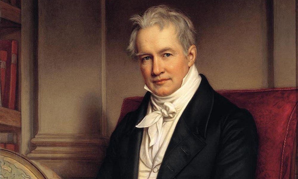
Alexander von Humboldt (1769 – 1859)
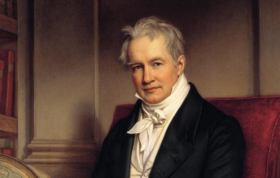
Alexander von Humboldt, a Prussian geographer, naturalist, and explorer, is widely regarded as one of the most influential figures in the history of geography. Born in Berlin, Germany, Humboldt was a true polymath, with interests and expertise spanning a wide range of fields, including botany, geology, and anthropology.
Humboldt’s most significant contribution to the field of geography was his work on the interconnectedness of natural phenomena. Through his extensive travels and observations, Humboldt developed a holistic view of the Earth, recognizing the complex interplay between climate, vegetation, and human activity. His work laid the foundation for the modern field of biogeography and helped to shape our understanding of the Earth as a complex and interconnected system.
In addition to his work on biogeography, Humboldt also made significant contributions to the field of physical geography through his studies of the Earth’s magnetic field, climate, and geology. His work in these areas helped to establish geography as a distinct scientific discipline and laid the foundation for future generations of geographers and earth scientists.
Humboldt’s legacy lives on to this day, with his holistic approach to the study of the Earth and its natural phenomena continuing to inspire and inform the work of geographers and earth scientists around the world. His extensive travels and observations, chronicled in his many books and articles, have provided a wealth of knowledge and insight into the natural world and have helped to shape our understanding of the Earth and our place in it.
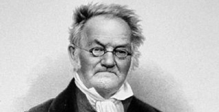
Carl Ritter (1779 – 1859)

Carl Ritter, a German geographer and historian, is widely regarded as one of the founders of modern geography. Born in Quedlinburg, Germany, Ritter was a pioneer in the field of comparative geography, which seeks to understand the relationships between human activity and the natural environment.
Ritter’s most significant contribution to the field of geography was his work on the concept of “Erdkunde” or “earth science.” In his view, geography was not simply the study of the Earth’s physical features, but rather a holistic discipline that encompassed all aspects of the natural world and human activity. Ritter’s work helped to establish geography as a distinct scientific discipline and laid the foundation for future generations of geographers and earth scientists.
Ritter’s comparative approach to geography was particularly influential, as it emphasized the importance of understanding the relationship between human activity and the natural environment. Through his extensive travels and observations, Ritter developed a deep understanding of the ways in which human societies interact with and shape the natural world, and his work helped to establish the field of human geography as a distinct area of study.
In addition to his work on comparative geography, Ritter also made significant contributions to the field of cartography through his creation of detailed maps and atlases. His “Erdkunde im Verhältnis zur Natur und zur Geschichte des Menschen” (Geography in Relation to Nature and the History of Mankind), published in 19 volumes between 1817 and 1859, was a groundbreaking work that helped to establish the format for modern geographic works.
Ritter’s legacy lives on to this day, with his holistic approach to the study of the Earth and its natural and human phenomena continuing to inspire and inform the work of geographers and earth scientists around the world. His emphasis on the interconnectedness of human activity and the natural environment has helped to shape our understanding of the complex and dynamic world we live in.
Paul Vidal de la Blache (1845 – 1918)

Paul Vidal de la Blache, a French geographer and professor, is widely regarded as one of the most influential figures in the history of modern geography. Born in Pézenas, France, Vidal de la Blache was a pioneer in the field of human geography, which seeks to understand the relationship between human activity and the natural environment.
Vidal de la Blache’s most significant contribution to the field of geography was his work on the concept of “possibilism.” In contrast to the deterministic views of earlier geographers, who believed that the natural environment dictated the course of human activity, Vidal de la Blache argued that human societies have the ability to shape and adapt to their environment. This view, which emphasized the importance of human agency and creativity, helped to establish human geography as a distinct area of study and laid the foundation for future generations of geographers and social scientists.
In addition to his work on possibilism, Vidal de la Blache also made significant contributions to the field of regional geography through his studies of the geography of France. His “Tableau de la géographie de la France” (Tableau of the Geography of France), published in 1903, was a groundbreaking work that helped to establish the format for modern regional geographic studies.
Vidal de la Blache’s legacy lives on to this day, with his emphasis on the importance of human agency and creativity in shaping the natural environment continuing to inspire and inform the work of geographers and social scientists around the world. His work has helped to shape our understanding of the complex and dynamic relationship between human societies and the natural world, and has laid the foundation for the modern field of human geography.
Ellen Churchill Semple (1863 – 1932)
Ellen Churchill Semple, an American geographer and professor, is widely regarded as one of the most influential figures in the history of American geography. Born in Louisville, Kentucky, Semple was a pioneer in the field of anthropogeography, which seeks to understand the relationship between human activity and the natural environment.
Semple’s most significant contribution to the field of geography was her work on the concept of “environmental determinism.” In contrast to the possibilistic views of earlier geographers, who emphasized the importance of human agency and creativity in shaping the natural environment, Semple argued that the natural environment plays a critical role in shaping human activity and culture. Her work, which drew on the theories of German geographer Friedrich Ratzel, helped to establish environmental determinism as a dominant paradigm in American geography in the early 20th century.
In addition to her work on environmental determinism, Semple also made significant contributions to the field of regional geography through her studies of the geography of the Mediterranean region. Her “Influences of Geographic Environment” (1911) was a groundbreaking work that helped to establish the format for modern regional geographic studies and laid the foundation for future generations of geographers and anthropologists.
Semple’s legacy, while controversial due to her association with environmental determinism, which has been widely criticized for its reductionist and deterministic views of human behavior, nonetheless played a significant role in shaping the development of American geography in the early 20th century. Her emphasis on the importance of the natural environment in shaping human activity and culture has helped to shape our understanding of the complex and dynamic relationship between human societies and the natural world.
Carl O. Sauer (1889 – 1975)

Carl O. Sauer, an American geographer and professor, is widely regarded as one of the most influential figures in the history of modern geography. Born in Warrenton, Missouri, Sauer was a pioneer in the field of cultural geography, which seeks to understand the relationship between human culture and the natural environment.
Sauer’s most significant contribution to the field of geography was his work on the concept of “cultural landscapes.” In contrast to the environmental deterministic views of earlier geographers, who emphasized the importance of the natural environment in shaping human activity and culture, Sauer argued that human societies play a critical role in shaping and transforming the natural environment. His work, which drew on the theories of German geographer Otto Schlüter, helped to establish cultural geography as a distinct area of study and laid the foundation for future generations of geographers and anthropologists.
In addition to his work on cultural landscapes, Sauer also made significant contributions to the field of historical geography through his studies of the pre-Columbian Americas. His “The Early Spanish Main” (1966) was a groundbreaking work that helped to shed light on the complex and dynamic history of the Caribbean region and laid the foundation for future generations of historical geographers.
Sauer’s legacy lives on to this day, with his emphasis on the importance of human culture in shaping and transforming the natural environment continuing to inspire and inform the work of geographers and anthropologists around the world. His work has helped to shape our understanding of the complex and dynamic relationship between human societies and the natural world, and has laid the foundation for the modern field of cultural geography.
Doreen Massey (1944 – 2016)
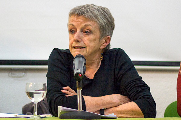
Doreen Massey, a British geographer and social scientist, is widely regarded as one of the most influential figures in the history of modern geography. Born in Manchester, England, Massey was a pioneer in the field of feminist geography, which seeks to understand the ways in which gender relations shape and are shaped by geographic processes and spaces.
Massey’s most significant contribution to the field of geography was her work on the concept of “power-geometry.” In her view, space and place are not neutral or static entities, but rather are constantly being produced and reproduced through the unequal power relations that exist between different social groups. Her work, which drew on the theories of French philosopher Michel Foucault, helped to establish feminist geography as a distinct area of study and laid the foundation for future generations of geographers and social scientists.
In addition to her work on power-geometry, Massey also made significant contributions to the field of economic geography through her studies of the spatial dimensions of economic inequality and globalization. Her “Spatial Divisions of Labour” (1984) was a groundbreaking work that helped to shed light on the ways in which the global economy is structured and organized across geographic space.
Massey’s legacy lives on to this day, with her emphasis on the importance of power relations and social justice in shaping geographic processes and spaces continuing to inspire and inform the work of geographers and social scientists around the world. Her work has helped to shape our understanding of the complex and dynamic relationship between space, place, and social inequality, and has laid the foundation for the modern field of feminist geography.
David Harvey (1935 – present)
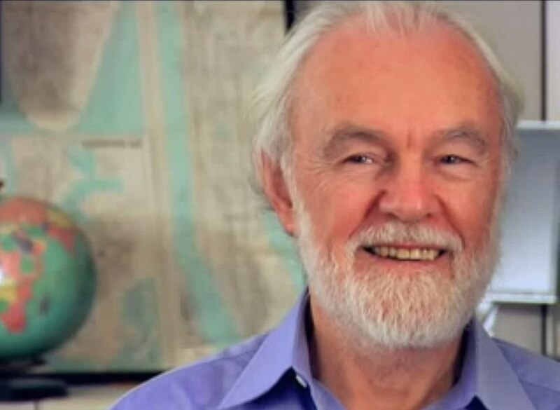
David Harvey, a British-American geographer and social theorist, is widely regarded as one of the most influential figures in the history of modern geography. Born in Gillingham, England, Harvey is a pioneer in the field of Marxist geography, which seeks to understand the ways in which capitalist social relations shape and are shaped by geographic processes and spaces.
Harvey’s most significant contribution to the field of geography has been his work on the concept of “uneven geographical development.” In his view, the capitalist mode of production necessarily produces spatial inequalities, as capital seeks to maximize profits by moving to areas with lower costs of production and higher rates of exploitation. His work, which draws on the theories of Karl Marx and other critical social theorists, has helped to establish Marxist geography as a distinct area of study and has laid the foundation for future generations of geographers and social scientists.
In addition to his work on uneven geographical development, Harvey has also made significant contributions to the fields of urban studies and social theory through his analyses of the role of cities in the global economy and the ways in which social movements and political struggles are shaped by and shape urban spaces. His “Social Justice and the City” (1973) and “The Condition of Postmodernity” (1989) are considered classic works in the field of critical urban studies.
Harvey’s legacy continues to shape the discipline of geography and beyond, with his emphasis on the importance of understanding the ways in which capitalist social relations shape and are shaped by geographic processes and spaces continuing to inspire and inform the work of geographers, social scientists, and activists around the world. His work has helped to deepen our understanding of the complex and dynamic relationship between space, place, and social inequality, and has provided critical tools for imagining and fighting for a more just and equitable world.
Conclusion
The geographers highlighted in this article represent some of the most influential and groundbreaking figures in the history of the discipline. From the ancient world to the present day, these scholars have made significant contributions to our understanding of the complex and dynamic relationship between human societies and the natural world, and have helped to establish geography as a vital and vibrant field of study.
Through their work on topics ranging from cartography and exploration to cultural landscapes and social inequality, these geographers have pushed the boundaries of what is possible in the discipline and have laid the foundation for future generations of scholars and practitioners. Their legacies continue to shape the field of geography and beyond, inspiring new generations of geographers to ask critical questions, challenge dominant paradigms, and work towards a more just and sustainable world.
As we reflect on the contributions of these influential geographers, it is important to recognize the ongoing relevance and importance of geographic thought and practice in the 21st century. In an era of rapid environmental change, growing social and economic inequality, and increasing global interconnectedness, the insights and tools of geography are more important than ever before. By building on the work of these pioneering scholars and continuing to push the boundaries of what is possible in the discipline, geographers have the potential to play a vital role in shaping a more just, sustainable, and equitable future for all.